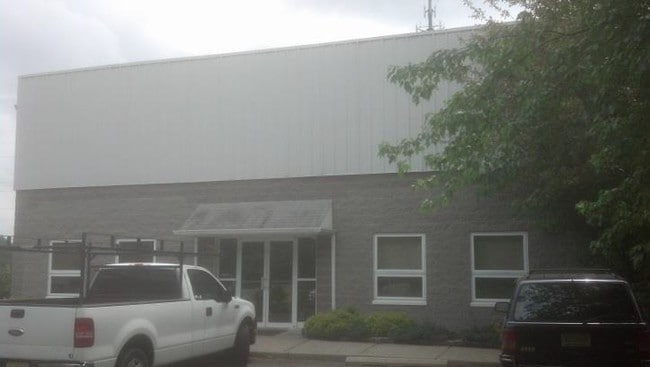
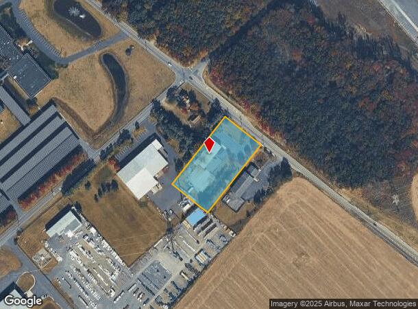
Property Record
223 Democrat Rd, Mickleton, NJ 08056


NEARBY LISTINGS FOR SALE OR LEASE
Property Detail
223 Democrat Rd
03-00103-0000-00022-02
Gloucester
Warehouse
New Jersey
X
22.2
34015C0067F
1.69 AC
2024
Gloucester County
2025
Philadelphia
500602
Philadelphia-Camden-Wilmington, PA-NJ-DE-MD
8,500 SF
DEMOGRAPHICS near 223 Democrat Rd
1 Mile
3 Mile
5 Mile
2024 Total Population
1,103
18,926
50,226
2029 Population
1,136
19,572
51,704
Pop Growth 2024-2029
+ 2.99%
+ 3.41%
+ 2.94%
Average Age
42
40
41
2024 Total Households
425
7,016
19,306
HH Growth 2024-2029
+ 3.06%
+ 3.51%
+ 2.99%
Median Household Inc
$98,986
$88,106
$90,388
Avg Household Size
2.60
2.70
2.60
2024 Avg HH Vehicles
2.00
2.00
2.00
Median Home Value
$268,014
$278,160
$287,704
Median Year Built
1973
1965
1977
Nearby Places
Map Layers
Map Styles
 Street
 Aerial
- Restaurants
- Banks
- Shops
- Fitness
- Groceries
PUBLIC TRANSPORTATION
AIRPORT
Philadelphia International
DRIVE
WALK
Distance
Philadelphia International
27 min
16.8 mi
Trenton Mercer
DRIVE
WALK
Distance
Trenton Mercer
69 min
49.5 mi
Freight Ports
Broadway Terminal - Pier 5
DRIVE
WALK
Distance
Broadway Terminal - Pier 5
18 min
12.3 mi
Nearby Properties
Address
Land Use
TOTAL SIZE
Lot Size
Zoning
Address
Land Use
TOTAL SIZE
Lot Size
Zoning
653.90 AC
Address
Land Use
TOTAL SIZE
Lot Size
Zoning
69.05 AC
M2
Address
Land Use
TOTAL SIZE
Lot Size
Zoning
71.49 AC
Address
Land Use
TOTAL SIZE
Lot Size
Zoning
28 AC
IC
Address
Land Use
TOTAL SIZE
Lot Size
Zoning
47.40 AC
C2
Address
Land Use
TOTAL SIZE
Lot Size
Zoning
Address
Land Use
TOTAL SIZE
Lot Size
Zoning
40.25 AC
M
Address
Land Use
TOTAL SIZE
Lot Size
Zoning
34.58 AC
Address
Land Use
TOTAL SIZE
Lot Size
Zoning
Address
Land Use
TOTAL SIZE
Lot Size
Zoning
Address
Land Use
TOTAL SIZE
Lot Size
Zoning
994 AC
R3
Address
Land Use
TOTAL SIZE
Lot Size
Zoning
111.40 AC
RRC
Address
Land Use
TOTAL SIZE
Lot Size
Zoning
30.76 AC
BP
Address
Land Use
TOTAL SIZE
Lot Size
Zoning
10.13 AC
Address
Land Use
TOTAL SIZE
Lot Size
Zoning
5.72 AC
R3
Address
Land Use
TOTAL SIZE
Lot Size
Zoning
5 AC
R1
Address
Land Use
TOTAL SIZE
Lot Size
Zoning
10.39 AC
RRC
Address
Land Use
TOTAL SIZE
Lot Size
Zoning
4.76 AC
Address
Land Use
TOTAL SIZE
Lot Size
Zoning
10.21 AC
RRC
Address
Land Use
TOTAL SIZE
Lot Size
Zoning
15.08 AC
R2A
Address
Land Use
TOTAL SIZE
Lot Size
Zoning
17.08 AC
BP
Address
Land Use
TOTAL SIZE
Lot Size
Zoning
22.05 AC
B1
Address
Land Use
TOTAL SIZE
Lot Size
Zoning
160.18 AC
Address
Land Use
TOTAL SIZE
Lot Size
Zoning
9.05 AC
R2
Address
Land Use
TOTAL SIZE
Lot Size
Zoning
31.77 AC
R2A
Address
Land Use
TOTAL SIZE
Lot Size
Zoning
4.19 AC
R2A
Address
Land Use
TOTAL SIZE
Lot Size
Zoning
Address
Land Use
TOTAL SIZE
Lot Size
Zoning
4.03 AC
R1
Address
Land Use
TOTAL SIZE
Lot Size
Zoning
761 SF
9.13 AC
R5
Address
Land Use
TOTAL SIZE
Lot Size
Zoning
556 SF
11.45 AC
The World's #1 Commercial Real Estate Marketplace
Connect with us
© 2026 CoStar Group
The information above has been obtained from sources believed reliable. While we do not doubt its accuracy we have not verified it and make no guarantee, warranty or representation about it. It is your responsibility to independently confirm its accuracy and completeness. Any projections, opinions, assumptions, or estimates used are for example only and do not represent the current or future performance of the property. The value of this transaction to you depends on tax and other factors which should be evaluated by your tax, financial, and legal advisors. You and your advisors should conduct a careful, independent investigation of the property to determine to your satisfaction the suitability of the property for your needs.